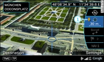
- Fig. 1 Google Earth™ map display
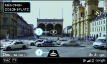
- Fig. 2 Google Earth™ map display with Google Street View
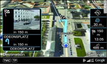
- Fig. 3 Google Earth™ map display
Applies to vehicles: with navigation system and car telephone kit
Important: Navigation mode must be activated Link, and the requirements for Audi connect services must be met Link.
Press the control button for Settings.
Turn the rotary pushbutton to Map display and press the rotary pushbutton.
To display the map with satellite pictures, turn the rotary pushbutton to Google Earth and press the rotary pushbutton.
For this map display the system uses data packets received online in the form of satellite pictures and combines these pictures with the road network from the standard Link map display. The MMI hard drive has a memory capacity of 2 GB for temporarily storing the map/navigation data received online (corresponds to map/navigation data for about 4000 km of route guidance). You can also use the loaded satellite pictures for route guidance without an active data connection as long as these pictures are stored on the hard drive.
Google Street View
With Google Street View, you can explore many locations all over the world virtually from the perspective of a pedestrian. Google Street View is available as soon as the symbol -1- Fig. 1 is shown in the legend.
To start Google Street View, turn the rotary pushbutton to select a scale below 30 m.
The following functions are available:
- Exploring a destination step-by-step - press the rotary pushbutton when the symbol -2- Fig. 2 is visible
- Zooming in/out of the current display (up to 4x) - turn rotary pushbutton to right/left -3-
- Rotating the view to the left/right or moving it up/down - move the joystick in the direction required
Additional information
In the Map content menu Link, you can activate the function to show additional information on the MMI display such as Panoramio photos of landmarks/special destinations. To show the map content, move the crosshairs onto an item on the map and press the rotary pushbutton. In the Additional information menu, you can now look at pictures of landmarks or special destinations, for example.
Note
- Did you know that you can choose from four different map types Link?
- Audi connect services are only available if you have a mobile phone contract that includes a data option and if you are in an area with mobile phone network coverage. Depending on your mobile phone tariff, you may be charged for receiving data packets online, especially if you are using the system abroad: We strongly recommend that you use a data flat rate. For more information, contact your service provider.
- You can delete the data stored from the Google Earth™ map display Link.
- Google Earth™ is an Audi connect service that is updated at regular intervals when it is called up. This can take a few seconds.
- When the Google Earth™ map display is switched on and the position 3D map type is selected, the MMI display automatically switches to the position 2D map while you are driving through a tunnel.
- For safety reasons, the Google Street View functions cannot be used while the vehicle is moving.
- The contents, volume and provider of Audi connect services offered can vary. For further information, please see www.audi.com/connect or ask an Audi dealer.