Applies to vehicles: with navigation system
After you have entered a destination or a tour and have started route guidance, the navigation information is displayed in the driver information system. If you select another function (e.g. radio) using the multi-function steering wheel, the navigation will be replaced by the function selected Link.
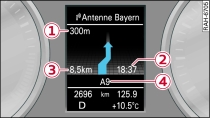
| -1- | Distance to turn-off |
| -2- | Estimated time of arrival |
| -3- | Total distance to destination/next stopover |
| -4- | Name of motorway, major road or street you are driving on. An arrow in front of the street name indicates that you are being directed to turn into the street. |
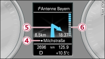
| -5- | Arrow indicating a turn-off. The direction of the turn-off is also displayed. |
| -6- | Bar graph. If an arrow is displayed, a bar graph will also appear. The fewer bars are displayed, the shorter the distance to the turn-off point. |
You can all up additional information from the on-board computer by scrolling the left thumbwheel on the multi-function steering wheel up or down.
If route guidance has not been started, the driver information system display will show a compass in the navigation display tab.
WARNING!
The route calculated by the navigation system is a recommendation of how best to reach a destination. Pay attention to traffic lights, no-stopping signs, lane change restrictions, one-way streets, etc.
Note
An exclamation mark "!" in front of the street name indicates that the navigation data of the MMI system do not contain all the information on this street or street section. Pay attention to traffic rules such as one-way streets or pedestrian zones.