|
- Fig. 1 Map with crosshairs switched off
Applies to vehicles: with navigation system
Select: NAV button > control button Settings.
Route criteria
Dyn. traffic avoidance: When the dynamic traffic avoidance function is on, the route is automatically optimised using the current traffic information. If the MMI system does not display a detour route although the dynamic traffic avoidance function is on and a traffic jam has been reported on the planned route, this is because the estimated time required for the detour is longer than the estimated time required for remaining on the route with the traffic jam.
Route type: You can select a short, fast or economical (eco) route.
Motorway1)/Vignette1)/Toll road1)/Tunnel1)/Ferry1)/Motorail1): If you do not want the navigation system to include motorways, vignette/toll roads, tunnels, ferries or motorail transit routes in the route calculation, you can set the option avoid1). You can use the Vignette option to set the countries for which you possess a vignette.
Closed certain times: Select avoid to exclude roads that are closed at certain times of the day (e.g. pedestrian zones) from the route calculation. When auto is selected, the MMI system will determine whether the restricted road can be included in the route calculation based on the entries stored in the navigation data.
Seasonally restricted: Select avoid to exclude roads that are closed during certain seasons (e.g. mountain passes) from the route calculation. When auto is selected, the MMI system will determine whether the seasonally restricted road can be included in the route calculation based on the entries stored in the navigation data.
HOV lanes2)3): Select avoid to exclude HOV lanes from the route calculation. Select allow to have the MMI system include HOV lanes in your navigation and display them on the map.
Map colours
day/night: The map is displayed with a light/dark background colour.
auto: When the lights are on, the map scheme will switch from day to night.
Map type
destination: The map indicates the destination and is set to face north.
2D driv. pos./2D north pos.: The map depicts the vehicle's current position. The map is set to face the direction of travel or north.
3D driv. pos.: When this function is activated, the current vehicle position is displayed in a three-dimensional map, and the map is set to face the direction of travel. If the map scale is more than 100 km, the map is set to face north.
overview: The entire route from the vehicle position to the final destination or next stopover is displayed on the map. The map scale varies according to the length of the route and is adapted automatically. The map is set to face north.
Map content
The display of map content such as traffic information, favourite destinations or restaurants can be switched on  and off.
and off.Additional info
Important: The route guidance function must have been started ►Link.
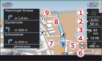
Route info: During route guidance, up to three upcoming manoeuvres together with their calculated distances and times are displayed -9- Fig. 1. In addition, the street you are currently on, upcoming turn-offs, traffic information or special destinations on the current route are displayed. Information e.g. on the traffic situation, or the next upcoming turn-off are shown on the bottom line.
off: No additional info is shown.
Auto zoom
on: The map scale is selected automatically according to the category of the road you are on (motorway, major road, other road) to ensure that you always have the best possible overview of the route ahead. When there is an upcoming turn-off, the map display will automatically zoom in for a better view of the details. This will be indicated in the map's legend menu -2- Fig. 1.
Intersection: When route guidance is active and there are upcoming turn-offs, the map display will temporarily switch to a more detailed scale so that the road layout can be identified more easily.
off: The map scale you have set will remain unaltered.
Instrument cluster map setting
You can also have the map displayed in the driver information system. The following settings are possible irrespective of the map display on the MMI:
Map type: The map types 2D driv. pos., 2D north pos. and 3D driv. pos. can be selected for the display of the driver information system.
Instrument cluster map content: The display of map content such as traffic information, favourite destinations or restaurants in the driver information system can be switched on and off.
and off.The settings Map display and Map colours in the instrument cluster depend on the map display set on the MMI.
Online traffic data*
The Online traffic data function is switched on when the vehicle leaves the factory. You can select off at any time to deactivate the reception of online traffic data.
Online traffic data licence*
If the Online traffic information option has not yet been activated or if you wish to activate it again, select and confirm Activate online traffic data. If the licence is activated, its validity and expiration date will be displayed in this menu.
When the Reminder: licence validity option is switched on, a message will be shown on the MMI display three months before the licence expires.
Petrol station message
When the fuel gauge is below the reserve zone, a message will appear when this function is on. A list of nearby filling stations will be displayed when you confirm this message. When you select one of the filling stations, the route to its location will be calculated based on the current position of your car.
Speed display4)
You can switch the display of the maximum speed limit on motorways, dual carriageways and other major roads on and off if it is stored in the navigation data.
Voice guidance
Voice guidance: The navigation cues can be played in complete or compact form. You can use the traffic option to have the system play only those announcements on traffic obstructions that are relevant for your route. Select off if you do not want the system to play any navigation cues.
Navigation cues during call: You can switch the navigation cues while you are on the phone on or off.
or off.Entertainment volume: see ►Link.
Volume of spoken cues: see ►Link.
Delete favourites
You can delete stored favourites individually or all at once.
Delete myAudi special destinations*
Destinations that you import from your myAudi account to your MMI are automatically saved. You can delete them individually or all at once.
Presentation mode
Use the Presentation mode to plan and display a route effectively by displaying map contents or route criteria. You can enter your start location manually (Set start location) if, for example, you would like to calculate a route starting from a different position than the current position of the vehicle. Start the Presentation mode to simulate a route guidance.
Note
For further information on the online traffic data licence, please see www.audi.com/connect or ask an Audi dealer.
1) Not available in the Mexican market
2) This function is only available in the Mexican market.
3) High occupancy vehicle
4) Applies to vehicles without camera-based speed limit display only