|
Applies to: vehicles with navigation system and Audi connect (infotainment)
You can have the map display satellite images using the Google Earth map display.
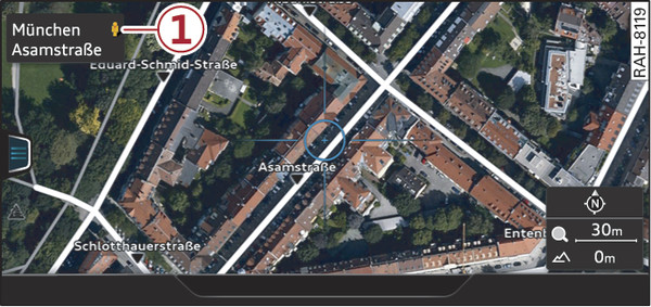
- Fig. 238 Google Earth map display
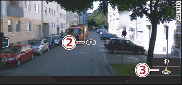
- Fig. 239 Google Earth map display with Google Street View
Important: The requirements for Audi connect (infotainment) must be met link►.
Press the NAV/MAP button repeatedly until the map is displayed.
Select: right control button > Map settings > Map display > Google Earth.
For this map display the system uses data packets received online in the form of satellite pictures and combines these pictures with the road network from the Standard map display. The MMI has a memory capacity of 2 GB for temporarily storing the map/navigation data received online (corresponds to map/navigation data for about 4000 km of route guidance). You can also use the loaded satellite pictures for route guidance without an active data connection as long as these pictures are stored.
Google Street View
With Google Street View, you can explore many locations all over the world virtually from the perspective of a pedestrian. Google Street View is available as soon as the symbol -1- Fig. 238► is shown in crosshairs mode.
To start Google Street View: Turn the rotary pushbutton to select a scale below 30 m.
The following options are available:
- To explore a destination step-by-step: Press the rotary pushbutton when the symbol -2- Fig. 239► is visible.
- To zoom in/out of the current display (up to 4x): Turn the rotary pushbutton to the left/right -3-.
- To navigate in the street view: Move your finger in the desired direction on the MMI touch pad.
Additional information
In the Map content menu link►, you can activate the function to show additional information on the infotainment display. To show the additional information move the crosshairs onto an item on the map and press the rotary pushbutton.
Note
- You can delete the data stored by the Google Earth map display using the Factory settings > Navigation and online memory link►.
- Google Earth is an Audi connect (infotainment) service that is updated at regular intervals when it is called up. This can take a few seconds.
- When the Google Earth map display is switched on and the position 3D map type is selected, the map display automatically switches to the position 2D map while you are driving through a tunnel.
- For safety reasons, the Google Street View functions cannot be used while the vehicle is moving.
- Please also observe the notes in the chapter link►.
- Further information can be found on the Internet at www.audi.com/connect.