Applies to vehicles: with navigation system
Select: NAV button > control button Settings.
The route is calculated according to various criteria.
Route criteria
Dyn. traffic avoidance: When the dynamic traffic avoidance function is on, the route is automatically optimised using the current TMC traffic information. If the MMI system does not display a detour route although the dynamic traffic avoidance function is on and a traffic jam has been reported on the planned route, this is because the estimated time required for the detour is longer than the estimated time required for remaining on the route with the traffic jam.
Alternative routes: When this function is on, up to three suggested routes and their characteristics are displayed in the legend menu on the MMI display. In the map display the route which was calculated on the basis of your criteria is highlighted. Turn and press the rotary pushbutton to select the possible alternative routes.
Route type: You can select a short, fast or economical route.
Motorway/Vignette1)/Toll road1)/Tunnel1)/Ferry1)/Motorail1): If you do not want the navigation system to include motorways, vignette/toll roads, tunnels, ferries or motorail transit routes in the route calculation, you can set the option avoid1).
Closed certain times: Select avoid to exclude roads that are closed at certain times of the day (e.g. pedestrian zones) from the route calculation. When auto is selected, the MMI system will determine whether the restricted road can be included in the route calculation based on the entries stored in the navigation data.
Seasonally restricted: Select avoid to exclude roads that are closed during certain seasons (e.g. mountain passes) from the route calculation. When auto is selected, the MMI system will determine whether the seasonally restricted road can be included in the route calculation based on the entries stored in the navigation data.
Map colours
day/night: The map is displayed with a light/dark background colour.
auto: When the lights are on, the map scheme will switch from day to night.
Orientation
north2): To set the map to face north.
dir. of travel: To set the map to face the direction of travel. If the map scale is more than 100 km, the map is set to face north to make orientation easier.
auto: If the scale is less than 5 km, the map is set to face the direction of travel. If the scale is more than 5 km, the map is set to face north.
Map type
destination: The destination is marked with a chequered flag. The map indicates the navigation destination and is set to face north.
position 2D: The map depicts the vehicle's current location. The map orientation corresponds to the setting in the Orientation menu Link.
position 3D: When this function is activated, the current vehicle position is displayed in a three-dimensional terrain model, and the map is set automatically to face the dir. of travel. If the map scale is more than 100 km, the map is set to face north. Any existing three-dimensional town models are shown on the display when the scale is set to between 30 m and 100 m; three-dimensional landmarks are displayed when the scale is between 30 m and 200 m.
overview: The entire route from the vehicle position to the final destination is displayed on the map. The map scale varies according to the length of the route. The map is set to face north.
Map content
The display of map content such as traffic information, favourite destinations or restaurants can be switched on  and off.
and off.The options available in the Map content menu depend on which map display is selected Link.
Additional info
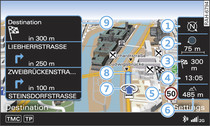
If this function is on, the next three turn-offs together with the calculated distances and arrival times are shown on the MMI display -9- Fig. 1 during route guidance.
In addition, the street you are currently on, upcoming turn-offs, traffic information or special destinations on the current route are displayed.
The next turn-off is listed at the bottom of the list.
Automatic zoom
on: The map scale is selected automatically according to the category of the road you are on (motorway, major road, other road). When there is an upcoming turn-off, the map display will automatically zoom in for a better view of the details.
Intersection: When route guidance is active and there are upcoming turn-offs, the map display will temporarily switch to a more detailed scale so that the road layout can be identified more easily.
off: The map scale you have set will remain unaltered.
Petrol station message
When the fuel gauge is below the reserve zone, a message will appear when this function is on. Confirm this message, and a list of petrol stations in the vicinity will be displayed. When you select one of the petrol stations, the route to this station will be calculated based on the current position of your car.
Speed display
You can switch the display of the maximum speed limit on motorways, dual carriageways and other major roads on and off if it is stored in the navigation data.
Voice guidance
The navigation cues in can be played in complete or compact form. Select off if you do not want the system to play any navigation cues.
Press the  button
Fig. 2 to play a voice guidance cue.
button
Delete last destinations
The destinations that were last entered are stored automatically. You can delete them individually or all at once.
Presentation mode
Use the Demo mode to plan and display a route effectively by displaying map contents or route criteria. You can enter your start location manually (Set start location) if, for example, you would like to calculate a route starting from a different position than the current position of the vehicle. Start the Demo mode to simulate a route guidance.
1) Not available in the Mexican market
2) Only for map type position 2D